When you click on links to various merchants on this site and make a purchase, this can result in this site earning a commission. Affiliate programs and affiliations include, but are not limited to, the eBay Partner Network.
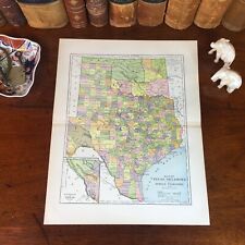
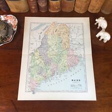
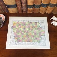
Original 134-year-old Antique Map of New York Drawn & Engraved by E.F. Fisk for the 1890 Edition of The People's Cyclopedia of Universal Knowledge: A Compendium of Invaluable Reference in all Departments of the Arts and Life; Illustrated with More than Five Thousand Engravings and Over One Hundred Color Maps of Each State, Principal City, and Territory of the United States, Continents, and Countries Across the Globe. Intricate Detail of County Boundaries, Cities, Towns, Railroads, along with Rivers, Lakes, and other Natural Landmarks. Fine Map for the Collector or Historian. Great for American History and Family Genealogy. Makes an Imaginative and Creative Gift. Easily Framed. Original Map Drawn & Engraved by E.F. Fisk for the 1890 Edition of The People's Cyclopedia of Universal Knowledge: A Compendium of Invaluable Reference in all Departments of the Arts and Life, the Whole Brought Down to the year 1890, with Pronunciation Conformed to Webster's Unabridged Dictionary, Illustrated with More than Five Thousand Engravings and Over One Hundred Color Maps of Each State, Principal City, & Territory of the United States, Continents, and Countries Across the Globe.NOT A REPRODUCTION.Edited by W.H. De Puy, A.M., D.D. and Assisted by a Corps of Special Contributors, Including: Thomas A. Edison, Inventor of the Telephone & Phonograph; John Clark Ridpath, Author of The History of The United States of America; A.G. Haywood, President Emory College, Oxford, Georgia; William F. Warren, President Boston University;Joseph Alden, President New York State School, Albany; Thomas Summers, Professor Vanderbilt University; and William Wells, Professor Union College. Engraved by E.F. Fisk. Published 1890 by Hunt & Eaton; New York and San Francisco; a Copy of the Title Page of Which is Included. Intricate Detail of County Boundaries, Cities, Towns, Railroads, along with Rivers, Lakes, and other Natural Landmarks. United States 1880 Census Population of Each County listed on Reverse. Fine Map for the Collector or Historian. Great for American History & Genealogy. Easily Framed. Dimensions:10.5"x13.5" Map is inExcellent/Very Goodcondition. No writings, marks, or tears. Mild foxing. Single fold as Issued. A Few of the Cities, Towns, Counties, Railroads, and Landmarks Shown on the Map Include:Watkins, Palmyra, Walworth, Delhi, Howes Cave, Cherry Valley, Colliers, Milford, Oneonta, Morris, Cooperstown, Avoca, Cold Springs, Angelica, Vandalia, Allegany, Hardy, Cadiz, New York City, Long Island, Adirondack Mountains, St. Lawrence County, Brooklyn, Buffalo, Rochester, Albany, Syracuse, Troy, Utica, Binghamton, Auburn, Yonkers, Elmira, Newburg, Oswego, Cohoes, Poughkeepsie, Kingston, Rome, Jamestown, Schenectady, New Brighton, Lockport, Watertown, Stapleton, Middletown, Saratoga Springs, Ithaca, Mount Vernon, Hudson, Peekskill, Geneva, Johnstown, Olean, Greenbush, Batavia, Tonawanda, Jamaica, Niagara Falls, Catskill Mountains, Malone, Norwich, Port Chester, West New, Oneida, Seneca Falls, Plattsburg, New Rochelle, Glens Falls, Canandaigua, Haverstraw, Hempstead, Albion, Medina, Lyons, Whitehall, Suspension Bridge, Waterloo, Ogdensburg, Penn Yan, Nyack, Fulton, Brockport, Sag Harbor, Bay Shore, Carthage, Ticonderoga, Far Rockaway, Canastota, Newark, Ellenville, Waterford, Fredonia, Herkimer, Clyde, Canton, Fairport, Waverly, White Plains, Ilion, Potsdam, Dansville, Tarrytown, Homer, Huntington, Ballston Spa, Fishkill-on-the-Hudson, Addison, Bay Shore, Canisteo, Allegany, Port Jefferson, Athens, Waterville, Walden, Mount Morris, Walton, Wellsville, Owego, Greenbush, Flushing, Corning, Cortland, Port Jervis, Dunkirk, Hoosick Falls, Goshen, Sandy Hill, Riverhead, Camden, Attica, Chatham, Westfield, Kings County, Seneca County, Westchester County, Yates County, Port Henry, Cameron Mills, Riverhead, Promised Land, Brookhaven, Setauket, Hopewell, Bath, Edgewood, East Hampton, Belmont, Mineola, Hawthorne, Rockland County, Spring Brook, Rathbone, Quaker Bridge, Summit, Lilly Dale, Elm, Mina, Watts, Sidings, Elmira, Lowman, Chenango, Richford, Andover, Dayton, Mendon, Lancaster, Alden, Collins, Bay View, Somerset, Ashford Station, Red Creek, Depew, Town Line, Riceville, Appleton, Wilson, Model City, Big Orchard, Almond, and many others. (If you are Interested if a particular city, town, family, or landmark is shown, email the name & vicinity and I will look to see if it is included on the map.) Imaginative & Creative Gift.
Some, to beautify their parlors, chambers, and studies . . . loveth, getteth, and useth, maps, charts, and geographical globes.
-John Dee, Advisor to Elizabeth I.